
Today’s news media gave a lot of attention to the resurvey of Mynydd Graig Goch which supposedly reclassified its summit from a “hill” to a “mountain”. Does this really make sense?
The distinction between “hill” and “mountain” has not been consistent in the UK. Most definitions go back to the 19th or early 20th Centuries. For example there is the 1 000 foot summit definition cited in The Englishman Who Went Up A Hill, But Came Down A Mountain. A summary of the storyline is given in the following Channel 4 excerpt.
In 1917, English surveyors Reginald (Grant) and George (McNiece) arrive in a small Welsh town to calculate the precise status of Ffynnon Garw, proudly described by the locals as “the first mountain in Wales”. Unfortunately, Ffynnon Garw is found to be somewhat short of the requisite 1 000 feet. Cue a less than ethical attempt by the locals to extend it, then persuade the surveyors to measure it again. “If it isn’t a mountain,” says one, “they might as well redraw the border and put us all in England. God forbid!”
However the current story views a “mountain” as being a summit above 2 000 ft. For example the BBC says
Mynydd Graig Goch in Snowdonia was originally put at 1 998ft (609m), just short of the magic 2 000ft (609.6m) that qualifies as a mountain.
But the walkers found its true height is six inches over 2 000ft (609.75m).
Many Scottish walkers though would regard “real mountains” as those summits over 3 000 ft listed by Sir Hugh Munro in 1891. In comparison, summits of 2 000 ft or 1 000 ft may seem puny.
In fact there is a wide variety of lists of peaks with a confusion of corresponding criteria. Sir Hugh’s famous Munro list is restricted to Scotland, the Hewitts (Hills in England Wales and Ireland over two thousand feet) and most other lists are based on heights of summits in feet. Many of these lists suffer from being disconnected from modern Ordnance Survey maps which have used metric contours since the early 1970s.
In commenting on today’s story, firstly credit should be given to John Barnard, Myrddyn Phillips and Graham Jackson for re-surveying Mynydd Graig Goch which is a thoroughly worthwhile activity. Similar activities have been undertaken by mountain enthusiasts in Scotland and England too. However, why is the 2 000 ft summit height so significant? Other people have historically seen 1 000 ft or 3 000 ft as more important.
For 21st century walkers a metric criterion would make sense as it would fit with the OS maps that have major contours every 50 metres and minor contours every 10 metres; feet are totally obsolete and awkward in this context. The official Goverment definition of a mountain is any land over 600 metres, so Mynydd Graig Goch was already officially a mountain even before the survey!
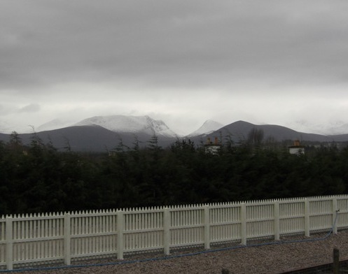
Lairig Ghru the highest pass through Cairgorms seen from Aviemore station
However most people envisage a “mountain” as being more than simply land over a certain elevation. For example, in the Cairngorms one of the lowest points is the Lairig Ghru pass at about 830 metres. Nobody would regard a mere hillock in that area as a “mountain” simply because of being above 2 000 ft or even 3 000 ft. In the Cairngorms the peaks rise above a high plateau. On the other hand on islands, all hills rise from almost sea level with 500 metre rises being not uncommon. Is a 500 metre hill rising out of the sea on say the Isle of Lewis any less worthy of the “mountain” title than a 1 000 metre high hillock in the Cairngorms?
Returning to the current news on Mynydd Graig Goch I wonder if we are asking the right question. It is great to have a more accurate reading of the summit but the Government already regarded it as mountainous terrain; the “magic height” was really 600 metres not 2 000 ft. The Government – like OS maps – has moved on from feet and inches in mapmaking three decades ago! But the really important question is whether Mynydd Graig Goch is a distinct peak.
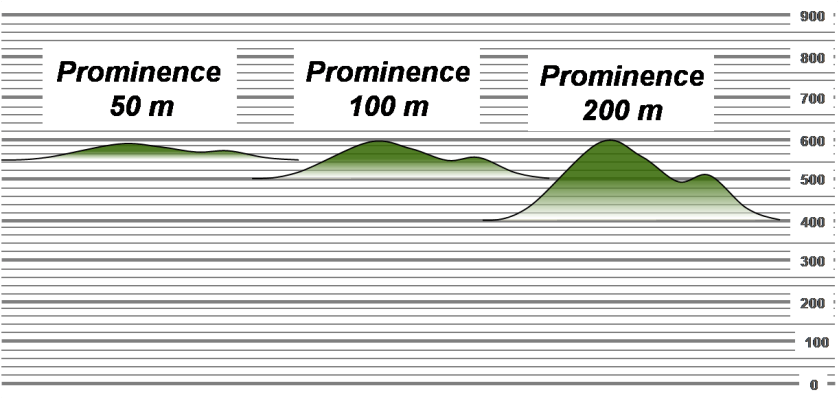
The point is that not every peak with the same summit height is equally prominent. In the diagram above, three peaks are shown each with a summit height of 600 metres. However the summit on the left with a prominence of 50 metres is relatively speaking a “bump” on a mountainous landscape compared with the one on the right which is -with prominence 200 metres – quite distinct and with a significant dip to the neighbouring peaks that descends much closer to sea level. The latter better merits the “mountain” title.
For too long in the UK we have classified peaks by summit height alone and ignored the equally important topographic prominence or distinctiveness of that summit. Classic lists of summits such as the Munros, Hewitts, Donalds, etc have tended to focus mainly on summit height. A new 21st Century classification of summits based on both height and prominence in metres is needed.
[Contributed by Roddy Urquhart]

The following is taken from the clause 1 of the Countryside and Rights of Way Act 2000 (c. 37): “mountain� includes … any land situated more than 600 metres above sea level. The definition does however have a few caveats which are related to freedom to roam rather than the formal definition of the word “mountain�.
I also had a look at the Dutch version of Wikipedia – the Dutch claim that they have a mountain on their territory. It is 323 m above sea level! I visited the site a few years ago – the peak itself is a few metres from the point where the Dutch, German and Belgian borders meet and is a popular picnicking spot with children’s playgrounds etc.
LikeLike
You might find these articles of interest:
http://www.wilderness-wales.co.uk/wm/explain.html
http://www.rhb.org.uk/marhofn/marhofn183/marhofn18308.htm
Humps and Bumps
Mark Jackson has compiled a 150-page ebook listing all 2994 British hills with Hundred Metre Prominence (Humps) in RHB format. This draws on work by Eric Yeaman, Rob Woodall, Clem Clements and others. It is available for download from the RHB newsgroup in PDF (with maps) and plain text format, along with Mark’s regional listings of hills with 30m prominence (relative height). So far he is up to 7082 hills and still going.
I like the way hump works out as HUndred Metre Prominence.
http://www.defra.gov.uk/wildlife-countryside/consult/access/statut.htm
The UK may define a mountain as 600 m, but a the Scots still define a Munro as 914.4 m. This needs to be changed to 900 m.
LikeLike
Fascinating – I always wondered what the official definition of a mountain was. I like hiking up mountains and hills, especially in the Lake District and the Yorkshire Dales.
LikeLike
I disagree with Dan’s comment that the definition of the Munros needs to be changed. It is a classification that was appropriate when it was first developed and as such that classification should be retained, but with the definition written in metric units with the imperial equivalent being givev in brackets. Thus the Munros would be defined as being peaks over “914.4Â m (3000Â ft)”.
I think that the use of dual units is justified here – “3000Â ft” shows that the classification was somewhat arbitrary while “914.4Â m” enables climbers to relate to modern-day maps.
As an aside, the concept of minimising the impact when a change in definition is made is fundemental to the development of the metric system. Whenever a definiton of any of the metric units is changed, the new definition is adjusted so as to minimise the impact of the change.
LikeLike
There is an interesting parallel to what Martin describes which is the road traffic rules. The rule states that an automatic speed limit of 30 mph exists where there is a system of street lights “placed not more than 183 metres apart”… almost exactly 200 yards. Interestingly the document also states “(in Scotland 185 metres)”.
LikeLike
Martin, your point is taken, but I believe that making exceptions is what will keep the muddle going and the imperialists empowered to demand more exceptions.
Even your idea to add imperial in parentheses is encourages the muddle. why not then do it everywhere?
In this case it looks awful to have a nonsensical metric number next to a rounded imperial number. The best thing for metrication is to redefine all the old rounded imperial limits into nice rounded metric limits where-ever they exist. Even if the majority of limits have already been redefined and this just leaves a few imperial limits, those few will be a thorn in the side of full metric usage and allow the muddle to continue indefinitely.
Presently the British definition of a mountain is 600 m, where formerly it was 609.6 m (2000 ft). This definition was changed, so there is no reason the Munro can not be changed. History and culture are no reason not to move forward and progress.
LikeLike
Dan thanks for providing some useful links. Alan Dawson’s Relative Hills of Britain (list of hills with prominence over 150 metres) was groundbreaking as the first consistent list of hills in the whole of Great Britain. The Humps take that a stage further, though both lists cover much more than mountains e.g. hills in south eastern England.
However, I do not agree that in Scotland Murnos are synonymous with mountains. They are simply a popular list of the higher mountains. Most Scots would see the peaks of Arran e.g. Cir Mhor (799 m http://www.geograph.org.uk/photo/240017) or the peaks of West Sutherland e.g. Suilven (731 m http://www.geograph.org.uk/photo/451470) as “mountains” although they are not high enough to be in Munro’s Tables. These peaks are certainly very prominent compared with some on Munro’s list even if their summits are lower.
I also do not think that the Munro’s Tables are likely to be redefined. They have a clear heigh criterion (3 000 ft) but an undocumented “separation”. The tradition of Sir Hugh Munro is lovingly maintained by the Scottish Mountaineering Club despite them doing everything else in metric.
Incidently Alan Dawson also created a list which used the same height criterion but a metric prominence criterion which he called the “Murdos” (http://bubl.ac.uk/org/tacit/tables/murdos/).
LikeLike
Mynydd Graig Goch is certainly a distinct peak. From where we live on its western flank the mountain rears up to its craggy summits. From the south, these summits can be seen as two distinct crags at the western end of and standing above the general height of the Nantlle Ridge.
The top 1/3 is mostly craggy outcrops; the next 1/3 down is mostly heather – hence the name (“Red Crag”) enclosed by extensive drystone walls of the Rhyolitic Tuff that the mountain is largely composed of; and below that both open and enclosed fridd, with boggy areas (Habitat for larks, curlews, sundews.) The river Nant Cyll (or Call) that appears in one of the tales in the Mabinogion rises from several springs on the north west flank of the mountain and skirts round separating the mountain from agricultural land before cutting away west through the fields. (Dragonflies, heron, bats.) Further round the mountain on the south west flank is the spring Ffynnon Wen that supplied water for many years to the town of Criccieth. Burnt mound, hut circles and ancient field systems. Mae bobl yn siarad Gymraeg o hyd. There is more to a mountain than its height….
LikeLike
I disagree. Mountains are great elevated land surface which are as a result of intense actions of internal forces.
LikeLike