
Observant readers might have noticed white pillars with blue bands and red reflector strips along the edges of motorways and on certain dual carriageway A-roads. These are called location marker posts. Some might have also noticed blue signs with the road number and other information along England’s (but not Scotland’s, Wales’s or Northern Ireland’s) roads. These are called driver location signs. They are to the road engineers what postcodes are to the postal service.
Location marker posts are at 100 metre intervals and are used by road maintenance and emergency services to pinpoint locations on the road that might need attention or the location where motorists might be stranded (The picture below taken at kilometre 2.8 on the M27 shows a location marker post, a driver location sign and an emergency telephone).
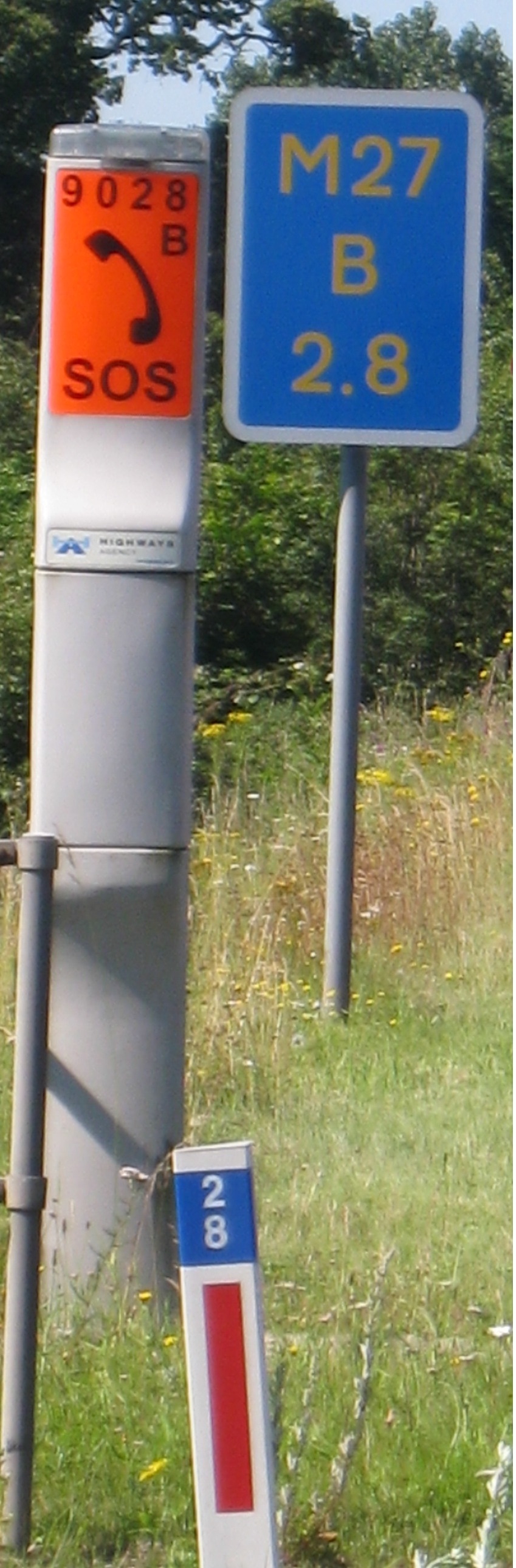
Prior to the turn of the millennium, motorists who were in trouble would (and still can) telephone the highways control room using emergency telephones. The closest location marker number (028 in this case) was encoded into the telephone number. With the advent of the mobile phone, drivers in trouble resorted to calling 999 from their mobile phones, so driver location signs were installed to help them communicate their positions to the relevant emergency service. The information on the driver location sign duplicated and extended the information on the marker posts. The road number is obvious and the “B” in the picture refers to the carriageway (“A” and “B” are in the direction of increasing and decreasing distances respectively. Slip roads have letters “J”, “K”, “L” and “M”).
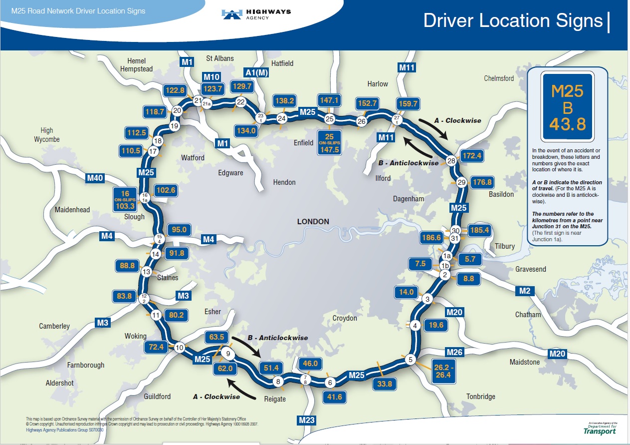
A decade ago, the Highways Agency (as it then was) started producing maps showing the relationship between driver location signs and motorway junctions. The Map for the M25 (see below) has been published and is reproduced here under the Open Government Licence scheme. Similar maps exist, but have not yet been published, though some have been leaked to the UKMA.
When I have spoken to people about driver location signs, the usual response that I get is “uh-what?” Clearly the public is unaware of these signs. This means that should they be involved in an incident they could well have trouble communicating their location when using a mobile phone to contact the emergency services.
Letter to the Minister
About two months ago, a UKMA member wrote to the minister via their MP, drawing attention to this with particular reference to the ambulance service. As everybody is aware, the ambulance service is under extreme pressure, and to quote a well-known supermarket, “Every little helps.”. The minister replied that the signs were “primarily for the benefit of organisations such as the emergency services and National Highways, rather than the general public.” He failed to address the issue of how a stranded member of the public should communicate their location to the emergency services. The minister went on to say that driver locations signs were not in the highway code – something which is patently wrong – See Rule 277 of the 2023 version of the Highway Code. He mentioned the e-Call device, which is now mandatory in vehicles manufactured in or after 2018, but failed to clarify that it will be a number of years before most of the cars on British roads are equipped with this device. The Minister’s reply is shown below.

After receiving his response, the UKMA member pointed out the factual errors to the minister via their MP, but the only response they got was from their MP saying that he was sorry that they were not happy with the minster’s response.
Breakdown on the A43
A few days before I sat down to write this blog article, my wife and I had the misfortune to suffer gearbox problems when travelling northwards on the A43. I was able to coax the car into a layby on the Silverstone bypass from where I phoned the AA. The bypass had a marker post showing that it was at “kilometre 42.4”. There was also a stone to commemorate the opening of the by-pass. I gave all the usual information to the AA and, apart from quoting the values on the marker post, I described my position using miles from Northampton and the fact that we were between Towcester and Silverstone.
After about three hours, the driver of an AA patrol van phoned us and when I described our location, he said that he was 30 miles away! It took another hour and was getting dark before he finally arrived. While we were driving to a point where he could drop us off, I asked him about location marker posts. He told me that he never used them.
What is the Government’s problem?
Why is the government reluctant to publicise the existence of driver location signs on motorways? Is it because they are in kilometres and the government fears that there will be an outcry if this fact is publicised? If so, then they are over-reacting – most people in the UK probably couldn’t care less, after all, how many people insisted on keeping “six feet apart” rather than “two metres apart” during the COVID lockdown? Although driver location signs, like post codes, are there to assist the relevant professionals, in both instances the public needs to use them to communicate critical information to the professionals. Finally, this over-reaction, which has been going on for years, is hindering the emergency services including, I believe, the hard-pressed ambulance service. What for? The minister’s ideology?
References:
Driver Location Signs – Frequently Asked Questions: https://web.archive.org/web/20101203121751/http://www.highways.gov.uk/business/16049.htm.
Wikipedia: Driver Location Sign: https://en.wikipedia.org/wiki/Driver_location_sign Highway Code Rule 277: https://www.gov.uk/guidance/the-highway-code/breakdowns-and-incidents-274-to-287)
Sources of Images:
Driver location sign picture: https://commons.wikimedia.org/wiki/File:M27_DLS_Tel_cropped.jpg
M25 Map: https://en.wikipedia.org/wiki/File:070921-Final_DLS_map.pdf
Minister’s letter: The author

Just one thing I thought might be useful here. Last time I was in Northern Ireland, I noted on my drive from the airport to Belfast that the marker posts were closer together, comparing my odometer with the distances there appeared to be 32 to one mile, on the mainland a post every 1000 m equates to roughly (but not exactly) 16 to a mile. The markings on the posts also went up to 32.
I’ve not seen any documentation on this but it strikes me as odd that these posts work out to be 55 yards apart, or 1 per ¼ furlong. This being the case it makes a further mockery of the use of imperial units on the roads. It did strike me that perhaps they were 50 metres apart but somebody had lost their nerve when it came to actually labelling them as such for political reasons.
This was about 10 years ago so I don’t know if it’s still the case… but on the flip side I did also notice at the time that all the milk in the supermarkets was in litres and not pints. I’d be interested to know if anybody else has been back to NI in recent years and has seen any changes.
LikeLiked by 1 person
The signs are shown in the Hong Kong’s version of the Highway Code.
https://www.td.gov.hk/en/road_safety/road_users_code/index/chapter_10_emergencies/breakdown_and_emergencies_/index.html
LikeLiked by 1 person
So, the location marker posts are not detailed in the Highway Code as it only includes signs that are likely to be ‘encountered’ by drivers. What does ‘encountered’ mean? Seen? Drivers see the location marker posts too, don’t they? I know I do. And the Highway Code is kept at a modest price and size to encourage maximum sales and usage in the interest of road safety. How is it in the interest of road safety for motorists not to be able to relay the information on a location marker post to the emergency services, if need be? I don’t understand that. It’s like saying the public shouldn’t be able to read signs such as ‘Fire Hydrant’ or ‘Dry Riser’ on buildings because they are for firefighters only. Moreover, how would the inclusion of information about location marker posts in the Highway Code affect the size and price of the Code? What would it add? Another double-sided page? The Minister’s answer is a joke, but a bad one.
LikeLike
The size and cost of the highway code book and road signs could be considerably reduced by removing duplicity, a point I am sure is not lost on ministers.
I do not understand how signage can be for the emergency services if the public are shielded from them such that they cannot communicate the information through lack of knowledge of their existence or function.
The DfT definitely has some sort of paranoid mentality as regards to metric, a bit strange as there is so much of transport that is in-separable from metric units that it would surely be much easier to go fully metric to avoid confusion rather that adding to it.
Re the Hong Kong highway code, I am surprised to see distance as ‘chainage’!
LikeLiked by 1 person
In the update/changes history of the Highway Code, the entry for 2021 includes the following:
“Updated Rule 277 to add images and ensure readers understand: … how to identify and communicate their location to emergency services“
https://www.gov.uk/guidance/the-highway-code/updates
The driver location sign image can be seen in Rule 277 of the current online edition of the Highway Code:
https://www.gov.uk/guidance/the-highway-code/breakdowns-and-incidents-274-to-287
Rule 277 includes the following:
“Communicating your location. How to identify your location to the emergency services.
…
Marker post or driver location sign
Quote the numbers and letters on marker posts or driver location signs which are located along the edge of the road.”
For the Minister to say that, “These signs are primarily for the benefit of organisations such as the emergency services“, is a bit like saying that addresses and postcodes are primarily for the Royal Mail and other delivery services. In both cases the public need to be aware of them, and know how to use them, in order for them to be of any use to professional organisations.
LikeLiked by 1 person
“These signs are primarily for the benefit of organisations such as the emergency services“
This statement is incorrect and show ignorance on the part of the Minister. Those signs were originally erected for road crews to do service on the road. It was discovered later that they could be used for emergencies.
LikeLike
It is not good that the Secretary of State for Transport gives an incorrect account of the Highway Code. Martin’s MP probably gave the only response he could when the error was pointed out. He was probably too embarrassed to say or do any more.
I don’t think there would be any public outcry if it were to be officially announced that these marker posts represented metric distances. After all, there are plenty of references to metric distances in the Highway Code. Tachographs work in metric. Public notices about road works used metric measurements. I have never heard any outcry about any of these.
Free Thinker’s thoughts remind me of a trip I took by express coach down the M1 to London in 1972. It was an opportunity for me to observe the roadside markers and how they worked. They appeared to be based on miles, and there were 16 to the mile, i.e. at half-furlong intervals. Were these markers removed and relocated when they were converted to metric, or were they already metric in disguise? (Half a furlong is close to 100 metres.) I don’t really know.
Like Brian, I was a little surprised to see “chainage” used in Hong Kong, a metric country as far as I can tell. However, Wikipedia describes the usage of the term as a general one for surveying distance with no precise measurement defined. The Indian definition of a “metric chain” of 20 metres is interesting, too.
https://en.wikipedia.org/wiki/Chain_(unit)
LikeLike
metricmac
Metric chains of 20m long were extensively used in this country.
I worked in the Land Survey Section of The City Engineers Department at Nottingham City Council from 1970 to 1974 and we used 20m chains every day for ‘chain and offset surveys’ Nottingham’s road building, repair and design were fully metric in 1970 as we’re the architects and planning departments.
On my first day at work, my boss, who was a WW2 Royal Engineers veteran, said to me: “Forget imperial measures, you will never use them again” I didn’t realise at the time that I had joined a profession that was one of the first to go metric.
LikeLike
So will cricket pitches in future be one metric chain long? Why, no! 12 cm off the length of the pitch? It would make the game too easy!
LikeLike
In cricket, the centre-point of the stumps is on the back edge of the bowling crease (22 yards are measured from the back edges of the bowling crease). Since the 1960’s, the reference point for the closest point from which a bowler may bowl is the popping crease which is 4 ft from the bowling crease. (Note – the term “bowling crease” is the name given before the 1960’s change in the laws. The stumps are between 1.375 and 1.5 inches in diameter. Thus the distance from the bowler’s reference point to the front of the stumps is “2 yds – 4ft – 1.5/2” or 18.878 metres.
If we wish to metricate, then we could
1) Decrease the distance between the two bowling creases to 20 metres
2) Reduce the distance between the bowling crease and the popping crease to 120 cm
3) Position the stumps such that the front face of the stumps, rather than the centre point lies on the edge of the blowing crease.
The effect of this would be to
1) reduce the distance between the bowler and the batsman by 7.8 cm
2) reduce the distance between the stumps and the batsman by 1 millimetre.
Compared to the changes in the laws regarding the closest point from which the bowler may bowl that occurred in the 1960’s 7.8 cm is nothing!
BTW, this evening I filled in my availability to umpire cricket matches this season.
LikeLiked by 1 person