
The Government have confirmed that there will be no more official publicity of driver location signs in a response to UKMA member Martin Vlietstra. Driver location signs use yellow font colour on a blue background with a white border and appear along the edges of motorways and on certain dual carriageway A-roads in England. They are normally spaced at 500 metre intervals.
Here is an example of a driver location sign:
a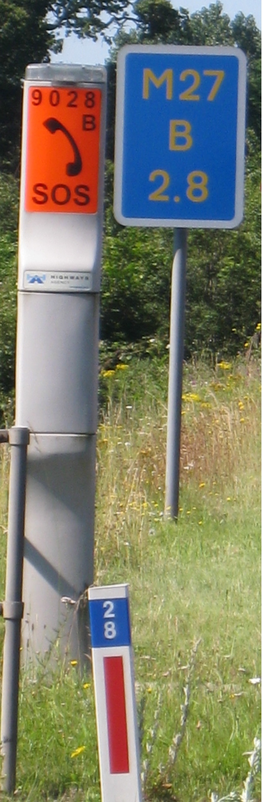
You can find more details about driver location signs in a previous Metric Views article. 1
Despite the fact that Wikipedia reported a survey that revealed 59% of respondents had seen such a sign and 76% of drivers did not know what the signs were for, the Government refuses to increase their publicity and tell drivers what the letters and numbers mean. 2 This is despite the fact that the Government admits that they are there for their benefit.
The latest version of the Highway Code tells you to read out a list of letters and numbers on a driver location sign for the emergency services but does not tell you what they mean. You have to look elsewhere to learn more about these signs. Unofficial sources such as Wikipedia and the AA explain the meaning of the letters and numbers on these signs. 2 3
Here is the response Mark Harper, Secretary of State for Transport, sent to Martin Vlietstra’s MP, confirming no increased publicity for driver location signs:

Was this decision made for ideological reasons? What don’t the Government want more drivers to know about these signs? Has it got something to do with the units the numbers represent? I think we can guess the answers to these questions.

There are many items within the Highway Code where we could possibly appreciate more information. Maybe the publishers see a need to compromise between providing more information and making the whole booklet too lengthy. I think that in the case of driver location signs, the intention is to locate the driver and nothing more. The signs achieve this.
Would drivers benefit from knowing the true meaning of the figures? Let us see.
The example pictured is very soon after the start of the M27 eastbound near Cadnam. The figure shows how far the origin of the distance is behind (letter B) the driver. I believe, from my personal experiences of driving this route, is that it is where the traffic lines start to divide in preparation to joining the motorway.
Unfortunately it is not so straightforward everywhere. Take the M3 for instance. Eastbound approaching London, one sees letters A’s with diminishing distance figures indicating an origin ahead. But as the M3 peters out into the A316 at Sunbury the distance figures are still quite large, indicating an origin at an unknown place a substantial distance ahead, along the A316 and maybe beyond.
Take another example, the M69. It has always been a puzzle to me why this road is so numbered. It effectively replaces a section of the A46, so I would have thought that the name A46(M) would have been more appropriate, and certainly would simplify direction signage. This is the treatment usually applied elsewhere, e.g. the A1 has several motorway stretches and these are all named A1(M). My best guess is that it is because its origin, just east of Coventry, gives it a number beginning with 6 because it lies in the sector between the A6 and the A1. Likewise, the A46 originates at Bath, and lies within the A4 and the A5 sector, so has a “4” number. However, as one drives from the A46 to join the M69 eastbound, one sees “B” signs with substantial three-figure distance figures, suggesting an origin a long way behind, possibly even as far as Bath. Could it be that this motorway was once planned to start much further west? Perhaps, but if that were the case then it should have a number starting with a 4.
Highway signage has a number of unanswered mysteries like this, most of which I’ll probably take to my grave. My point is that even if it were publicised that these numbers represented kilometres, (and even if we changed to showing kilometres on all road signs) it would not really help drivers, because in most cases it is not clear to which reference point the distance refers. We should perhaps accept that in this case drivers, rescue services and highways operatives have sufficient information for their needs.
However we can, and should, suggest in our campaign that given that these figures represent kilometres, it is inconsistent that other signage indicates miles.
LikeLiked by 1 person
@MetricMac: Your post dealt with two separate subject:
1. If you wish to collect information regarding road numbering, I suggest that you visit https://www.sabre-roads.org.uk/, a site for road geeks.
2. I do not get excited about the reference point for a series of location marker posts (or driver location signs), except when two or more roads share the same origin, such as the M1 and M6. I am more concerned with the difference between two marker posts close to points that that are of interest. Before starting a journey, I will have checked the marker posts associated with the various service areas that I will pass and wehn I am driving, I keep a track of how far it is to the next service area by looking at the driver location signs and doing a mental subtraction.
I agree that it would be useful if highway signs were to be erected that publicly acknowledged reference points in the towns that appear on road signs. To this end, I have toyed with the idea of the reference point being an oval sign with the town’s name on it, and possibly in smaller letters, supplementary information such as height above sea level, county coat of arms etc. Such signs would typically be on cross-roads, outside the village church etc.
LikeLike
If the emergency services, the Police, etc require distances to be communicated to them in kilometres, is it safe to assume that their vehicles are set to operate in metric units for distance and speed? That would seem very reasonable as everyone of working age employed in those services will have learnt metric units at school by now. So why have the rest of us been deprived of this benefit? Why do the two generations who have been taught metric as the country’s system of measurement since 1974 still have to contend with imperial units on road signs?
LikeLiked by 2 people
@Martin Vlietstra
1. Thanks for the web site link. I have had a quick look and I’ll look in more detail once I have finished preparing a report for the AGM.
2. The DFT would contend that drivers have the information that they need. On approaching a service area there is usually a sign stating how far it is ahead and also how far to the next one after it. There are also signs at various points showing distances to various places of interest. All these distances are in miles of course.
The advantage of using location markers in the way that you do to assess distances more accurately and frequently seems a good idea because these signs appear frequently. The pity is that they represent kilometres while other signage does not. This emphasises the point that we would be served better if all signage were to be in kilometres.
LikeLiked by 1 person
Metricmac wrote: “This emphasises the point that we would be served better if all signage were to be in kilometres.”
Indeed. Given that the ambulance services, the fire brigade and the Police all work in metric, as do the NHS and health professionals generally (as well as scientists, engineers, builders, etc), it is not unreasonable to draw the conclusion that metric is only considered fit to be used by the “professionals”, those who require precise measurements, of whatever kind, for their work. The rest of us are not considered clever enough, or worthy enough, to use the system taught in school, I suppose! I see it as a means of dividing society.
LikeLike